Local Government
East Fremantle
Region
Metropolitan
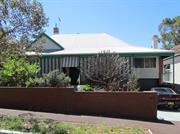
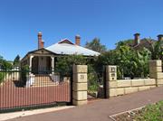
15 Bedford Street East Fremante
East Fremantle
Metropolitan
| Type | Status | Date | Documents |
|---|---|---|---|
| Heritage List | Adopted | 17 Nov 2015 |
| Type | Status | Date | Documents |
|---|---|---|---|
| (no listings) |
| Type | Status | Date | Grading/Management | |
|---|---|---|---|---|
| Category | ||||
| Local Heritage Survey | Adopted | 17 Nov 2015 | Category B | |
| Municipal Inventory | Adopted | 18 Nov 1997 | Category B | |
Individual Building or Group
| Epoch | General | Specific |
|---|---|---|
| Present Use | RESIDENTIAL | Single storey residence |
| Original Use | RESIDENTIAL | Single storey residence |
| Style |
|---|
| Federation Filigree |
| Federation Bungalow |
This information is provided voluntarily as a public service. The information provided is made available in good faith and is derived from sources believed to be reliable and accurate. However, the information is provided solely on the basis that readers will be responsible for making their own assessment of the matters discussed herein and are advised to verify all relevant representations, statements and information.
STATEMENT OF SIGNIFICANCE No 15 Bedford Street is a single storey house constructed in tuck-pointed brick with a tiled roof. It has historic and aesthetic value for its contribution to Woodside's high concentration of predominantly Federation period houses and associated buildings. The place contributes to the local community’s sense of place. The place has considerable heritage value for its intrinsic aesthetic value as a Federation Filigree style house. The place retains a high degree of authenticity and a high degree of integrity. The additions to the rear have no significance. AESTHETIC SIGNIFICANCE No 15 Bedford Street has considerable aesthetic value as a Federation Filigree style house. It retains most of the characteristic features of a dwelling of the type and period. HISTORIC SIGNIFICANCE No 15 Bedford Street has some historic value. It was part of the suburban development associated with the expansion of East Fremantle and the subdivision of W. D. Moore’s Woodside Estate from 1912. SCIENTIFIC SIGNIFICANCE N/A SOCIAL SIGNIFICANCE No 15 Bedford Street has some social value. It is associated with a significant area of middle class Federation and Inter-War period development which contributes to the community's sense of place. RARITY No 15 Bedford Street is not rare in the immediate context but Woodside has rarity value as a cohesive middle class suburb. CONDITION No 15 Bedford Street is in good condition. INTEGRITY No 15 Bedford Street retains a high degree of integrity. AUTHENTICITY No 15 Bedford Street retains a high degree of authenticity.
PHYSICAL DESCRIPTION No 15 Bedford Street is a single storey house constructed in tuck pointed brick with a hipped and gable tiled roof. It is a very fine expression of the Federation Filigree style. The front elevation is asymmetrically planned with a full width return roofed verandah. The verandah is set on turned timber posts. A timber filigree frieze and vertical timber balustrade span between the posts. The entry door is on the east elevation and addresses Bedford Street. The facade features single and multi-paned casement windows and a corner window suite. Sunhoods protect the windows on the Bedford Street elevation. The roofscape features render capped chimneys, dragon finials and crestings. The place retains its form and most details. Additions are to the rear. In 2016 the lot was subdivided to facilitate the construction of a two storey dwelling on Lot 406 to the south. Lot 406 no longer forms part of the heritage listing. Also at this time, a paved parking bay in the front garden and crossover from Bedford Street was constructed. The place is consistent with the building pattern in the Precinct. The place plays an important role in the pattern of development of a middle class suburb.
HISTORICAL NOTES Woodside is a relatively cohesive precinct where most of the places were constructed following the subdivision of W.D. Moore’s Estate commencing in 1912. Most of the lots were sold between 1912 and 1929 and the majority of buildings were completed in this time. Residences were substantial and of various Federation period styles distinguishing the area from the small worker’s cottages of Plympton. The Inter-War Bungalow style residence is also represented in Woodside. The Woodside Precinct remains largely intact in terms of original housing with little infill subdivision or replacement housing. OWNERS Unknown HISTORIC THEME Demographic Settlements - Residential Subdivision CONSTRUCTION MATERIALS Walls – Tuck pointed brick Roof – Tile PHYSICAL SETTING The residence is situated on a gently sloping site with a lych at the Canning Highway entry. A low brick wall with grille infill is located at the lot boundaries.
INTEGRITY No 15 Bedford Street retains a high degree of integrity. AUTHENTICITY No 15 Bedford Street retains a high degree of authenticity.
Good
This information is provided voluntarily as a public service. The information provided is made available in good faith and is derived from sources believed to be reliable and accurate. However, the information is provided solely on the basis that readers will be responsible for making their own assessment of the matters discussed herein and are advised to verify all relevant representations, statements and information.
East Fremantle
East Fremantle
Metropolitan
Constructed from 1910, Constructed from 1900
| Type | Status | Date | Documents |
|---|---|---|---|
| (no listings) |
| Type | Status | Date | Documents |
|---|---|---|---|
| (no listings) |
| Type | Status | Date | Grading/Management | |
|---|---|---|---|---|
| Category | ||||
| Fire & Rescue Service Heritage Inventory | Adopted | 30 Aug 1997 | ||
Historic Site
| Epoch | General | Specific |
|---|---|---|
| Present Use | GOVERNMENTAL | Fire Station |
| Original Use | GOVERNMENTAL | Fire Station |
| General | Specific |
|---|---|
| SOCIAL & CIVIC ACTIVITIES | Community services & utilities |
This information is provided voluntarily as a public service. The information provided is made available in good faith and is derived from sources believed to be reliable and accurate. However, the information is provided solely on the basis that readers will be responsible for making their own assessment of the matters discussed herein and are advised to verify all relevant representations, statements and information.
East Fremantle
View Tce upper/lower/ Pier St north side; Preston Point Rd; Locke Cresc cnr Woodhouse; Easton cutting
East Fremantle
Metropolitan
| Type | Status | Date | Documents |
|---|---|---|---|
| (no listings) |
| Type | Status | Date | Documents |
|---|---|---|---|
| (no listings) |
| Type | Status | Date | Grading/Management | |
|---|---|---|---|---|
| Category | ||||
| (no listings) | ||||
Historic site
This information is provided voluntarily as a public service. The information provided is made available in good faith and is derived from sources believed to be reliable and accurate. However, the information is provided solely on the basis that readers will be responsible for making their own assessment of the matters discussed herein and are advised to verify all relevant representations, statements and information.
East Fremantle
East Fremantle
Metropolitan
| Type | Status | Date | Documents |
|---|---|---|---|
| (no listings) |
| Type | Status | Date | Documents |
|---|---|---|---|
| (no listings) |
| Type | Status | Date | Grading/Management | |
|---|---|---|---|---|
| Category | ||||
| (no listings) | ||||
Historic Site
| Epoch | General | Specific |
|---|---|---|
| Present Use | RESIDENTIAL | Single storey residence |
This information is provided voluntarily as a public service. The information provided is made available in good faith and is derived from sources believed to be reliable and accurate. However, the information is provided solely on the basis that readers will be responsible for making their own assessment of the matters discussed herein and are advised to verify all relevant representations, statements and information.
opposite 39-49 Canning Hwy East Fremantle
East Fremantle
Metropolitan
| Type | Status | Date | Documents |
|---|---|---|---|
| (no listings) |
| Type | Status | Date | Documents |
|---|---|---|---|
| (no listings) |
| Type | Status | Date | Grading/Management | |
|---|---|---|---|---|
| Category | ||||
| Municipal Inventory | Adopted | 15 Aug 2006 | Category E | |
Other Built Type
| Epoch | General | Specific |
|---|---|---|
| Present Use | COMMERCIAL | Bank |
| Original Use | OTHER | Other |
This information is provided voluntarily as a public service. The information provided is made available in good faith and is derived from sources believed to be reliable and accurate. However, the information is provided solely on the basis that readers will be responsible for making their own assessment of the matters discussed herein and are advised to verify all relevant representations, statements and information.
Aesthetic, Historical & Rarity
Historic Theme: Occupations
Integrity: Very High
This information is provided voluntarily as a public service. The information provided is made available in good faith and is derived from sources believed to be reliable and accurate. However, the information is provided solely on the basis that readers will be responsible for making their own assessment of the matters discussed herein and are advised to verify all relevant representations, statements and information.
5 Alcester St East Fremantle
East Fremantle
Metropolitan
| Type | Status | Date | Documents |
|---|---|---|---|
| Heritage List | Adopted | 17 Nov 2015 |
| Type | Status | Date | Documents |
|---|---|---|---|
| (no listings) |
| Type | Status | Date | Grading/Management | |
|---|---|---|---|---|
| Category | ||||
| Municipal Inventory | Adopted | 15 Aug 2006 | Category B | |
Individual Building or Group
| Epoch | General | Specific |
|---|---|---|
| Original Use | RESIDENTIAL | Single storey residence |
| Present Use | RESIDENTIAL | Single storey residence |
| Style |
|---|
| Federation Bungalow |
This information is provided voluntarily as a public service. The information provided is made available in good faith and is derived from sources believed to be reliable and accurate. However, the information is provided solely on the basis that readers will be responsible for making their own assessment of the matters discussed herein and are advised to verify all relevant representations, statements and information.
Aesthetic & Representative No 5 Alcester Street is a single storey house constructed in limestone and brick with a corrugated iron roof. It has historic and aesthetic value for its contribution to Richmond's high concentration of predominantly Federation and Inter-War period houses and associated buildings. The place contributes to the local community’s sense of place. The place has considerable aesthetic value as a Federation Bungalow with sympathetic additions. The place retains a moderate to high degree of authenticity and a high degree of integrity. The garage and additions have no significance. AESTHETIC SIGNIFICANCE: No 5 Alcester Street has considerable aesthetic value as a Federation Bungalow. It retains most of the characteristic features of a dwelling of the type and period. HISTORIC SIGNIFICANCE: No 5 Alcester Street has some historic value. It was part of the suburban residential development associated with the expansion of East Fremantle and the subdivision of Stephen Henry Parker and James Morrison’s and then Walter Easton’s Estate from 1901. SOCIAL SIGNIFICANCE : No 5 Alcester Street has some social value. It is associated with a significant area of middle class Federation and Inter-War period development which contributes to the community's sense of place.
No 5 Alcester Street is a single storey house constructed in random course limestone and brick with a hipped and gable corrugated iron roof. It is a simple expression of the Federation Bungalow style. It is asymmetrically composed with a thrust gable bay and a part width skillion roofed verandah. A garage has been added to the west of the house. The verandah spans between the gable bay and garage and is supported by timber posts. The gable bay features a window under a sunhood. The window is a double hung sash window flanked by sidelights. There is a central door and hopper light flanked by another door. Walls are random course limestone with brick quoins. The gable is laid in brick stretcher bond. The place retains its form and most of its details. There are additions to the rear and side of the house. The place is consistent with the building pattern in the Precinct. The place plays an important role in the pattern of development of a middle class suburb.
Historic Theme: Demographic Settlement In September 1883 Stephen Henry Parker and James Morrison of Perth commenced subdivision of 65 acres of land to the north of Canning Road. The subdivision occurred at Swan Locations 63, 176, 219 and the south western portion of Swan Location 306. The subdivision included Preston Point Road, Alcester Gardens, Wolsely Gardens, Victoria Road, Alexandra Road, Parry Avenue, and Salvado Avenue. The Richmond Precinct was owned by Walter Easton and was named after the town of Richmond where Easton lived in England. In 1901 Easton’s sons subdivided Windsor Estate. New streets to the subdivision of the Windsor Estate were named after various members of the Easton family; Walter, Gill, Stratford and Morgan (later Osborne Road). Initially lot sizes were generous but sold at a slow rate. The initial development of the Richmond Precinct occurred at Canning Highway and Preston Point Road. Substantial residences were developed on these streets giving precedence to the future development of Richmond. The distinct architecture of Canning Highway and Preston Point Road distinguish Richmond from the surrounding area. By 1913 there were approximately 40 residences in the area between Preston Point Road and Alexandra Road. Osborne Road, Windsor Road and Gill Street had several buildings apiece by 1913. By 1931 approximately half the lots were developed. In 1921 Richmond Primary School was developed between Windsor and Osborne Road and several Inter-War residences were developed in the immediate area. In the 1930s the Workers’ Homes’ Board developed a number of weatherboard, asbestos, brick and tiled residences. Inter-War style front porches were preferred over Federation style full width verandahs. Redevelopments have occurred throughout the Richmond Precinct. Large lot sizes have allowed Richmond to be subject to the redevelopment of group and multiple housing. However, significant clusters of heritage dwellings remain throughout.
ARCHITECTURAL STYLE - Federation Bungalow
Integrity: Moderate INTEGRITY: No 5 Alcester Street retains a high degree of integrity.
Good
This information is provided voluntarily as a public service. The information provided is made available in good faith and is derived from sources believed to be reliable and accurate. However, the information is provided solely on the basis that readers will be responsible for making their own assessment of the matters discussed herein and are advised to verify all relevant representations, statements and information.
6 Alcester St East Fremantle
East Fremantle
Metropolitan
| Type | Status | Date | Documents |
|---|---|---|---|
| (no listings) |
| Type | Status | Date | Documents |
|---|---|---|---|
| (no listings) |
| Type | Status | Date | Grading/Management | |
|---|---|---|---|---|
| Category | ||||
| Municipal Inventory | Adopted | 15 Aug 2006 | Category C | |
Individual Building or Group
| Epoch | General | Specific |
|---|---|---|
| Present Use | RESIDENTIAL | Single storey residence |
| Original Use | RESIDENTIAL | Single storey residence |
| Style |
|---|
| Federation Carpenter Gothic |
This information is provided voluntarily as a public service. The information provided is made available in good faith and is derived from sources believed to be reliable and accurate. However, the information is provided solely on the basis that readers will be responsible for making their own assessment of the matters discussed herein and are advised to verify all relevant representations, statements and information.
Aesthetic & Representative STATEMENT OF SIGNIFICANCE: No 6 Alcester Street is a single-storey house constructed in timber with and an iron roof. It has some historic and aesthetic value for its contribution to Richmond's high concentration of mainly middle class Federation and Inter-War period houses and associated buildings. The place contributes to the local community’s sense of place. The place has some aesthetic value as a Federation Bungalow style house, with sympathetic additions. The place retains a moderate to high degree of authenticity and a high degree of integrity. AESTHETIC SIGNIFICANCE: No 6 Alcester Street has some aesthetic value as a Federation Bungalow style house. It retains most of the characteristic features of a dwelling of the type and period. HISTORIC SIGNIFICANCE: No 6 Alcester Street has some historic value. It was part of the suburban residential development associated with the expansion of East Fremantle and the subdivision of Stephen Henry Parker and James Morrison’s and then Walter Easton’s Estate from 1901. SOCIAL SIGNIFICANCE : No 6 Alcester Street has some social value. It is associated with a significant area of middle class Federation and Inter-War period development, which contributes to the community's sense of place.
No 6 Alcester Street is a single-storey timber framed and clad house with a hipped and corrugated iron roof. It is a simple expression of the Federation Bungalow style. It is asymmetrically composed with a part width skillion roofed verandah supported on timber posts, which terminates on a gabled thrust bay. There is a balustrade between posts. There is a centrally located front door and the windows are casement lights. Walls are weatherboard clad. There is a skillion roofed addition to the rear. The place retains its form and most of its details. The place is consistent with the building pattern in the Precinct. The place plays an important role in the pattern of development of a middle class suburb.
Historic Theme: Demographic Settlement In September 1883 Stephen Henry Parker and James Morrison of Perth commenced subdivision of 65 acres of land to the north of Canning Road. The subdivision occurred at Swan Locations 63, 176, 219 and the south western portion of Swan Location 306. The subdivision included Preston Point Road, Alcester Gardens, Wolsely Gardens, Victoria Road, Alexandra Road, Parry Avenue, and Salvado Avenue. The Richmond Precinct was owned by Walter Easton and was named after the town of Richmond where Easton lived in England. In 1901 Easton’s sons subdivided Windsor Estate. New streets to the subdivision of the Windsor Estate were named after various members of the Easton family; Walter, Gill, Stratford and Morgan (later Osborne Road). Initially lot sizes were generous but sold at a slow rate. The initial development of the Richmond Precinct occurred at Canning Highway and Preston Point Road. Substantial residences were developed on these streets giving precedence to the future development of Richmond. The distinct architecture of Canning Highway and Preston Point Road distinguish Richmond from the surrounding area. By 1913 there were approximately 40 residences in the area between Preston Point Road and Alexandra Road. Osborne Road, Windsor Road and Gill Street had several buildings apiece by 1913. By 1931 approximately half the lots were developed. In 1921 Richmond Primary School was developed between Windsor and Osborne Road and several Inter-War residences were developed in the immediate area. In the 1930s the Workers’ Homes’ Board developed a number of weatherboard, asbestos, brick and tiled residences. Inter-War style front porches were preferred over Federation style full width verandahs. Redevelopments have occurred throughout the Richmond Precinct. Large lot sizes have allowed Richmond to be subject to the redevelopment of group and multiple housing. However, significant clusters of heritage dwellings remain throughout.
Integrity: High INTEGRITY: No 6 Alcester Street retains a high degree of integrity.
Excellent
This information is provided voluntarily as a public service. The information provided is made available in good faith and is derived from sources believed to be reliable and accurate. However, the information is provided solely on the basis that readers will be responsible for making their own assessment of the matters discussed herein and are advised to verify all relevant representations, statements and information.
3 Alcester Street East Fremantle
East Fremantle
Metropolitan
| Type | Status | Date | Documents |
|---|---|---|---|
| Heritage List | Adopted | 17 Nov 2015 |
| Type | Status | Date | Documents |
|---|---|---|---|
| (no listings) |
| Type | Status | Date | Grading/Management | |
|---|---|---|---|---|
| Category | ||||
| Municipal Inventory | Adopted | 15 Aug 2006 | Category B | |
Individual Building or Group
| Epoch | General | Specific |
|---|---|---|
| Original Use | RESIDENTIAL | Single storey residence |
| Present Use | RESIDENTIAL | Single storey residence |
| Style |
|---|
| Victorian Regency |
| Type | General | Specific |
|---|---|---|
| Wall | RENDER | Other Render |
| Roof | METAL | Corrugated Iron |
| General | Specific |
|---|---|
| DEMOGRAPHIC SETTLEMENT & MOBILITY | Land allocation & subdivision |
This information is provided voluntarily as a public service. The information provided is made available in good faith and is derived from sources believed to be reliable and accurate. However, the information is provided solely on the basis that readers will be responsible for making their own assessment of the matters discussed herein and are advised to verify all relevant representations, statements and information.
Aesthetic & Representative
Victorian Bungalow w Simple Regency Influences
Historic Theme: Demographic Settlement
Integrity: High
Good
This information is provided voluntarily as a public service. The information provided is made available in good faith and is derived from sources believed to be reliable and accurate. However, the information is provided solely on the basis that readers will be responsible for making their own assessment of the matters discussed herein and are advised to verify all relevant representations, statements and information.
bounded by Alcester, Salvado & Parry Sts East Fremantle
East Fremantle
Metropolitan
| Type | Status | Date | Documents |
|---|---|---|---|
| (no listings) |
| Type | Status | Date | Documents |
|---|---|---|---|
| (no listings) |
| Type | Status | Date | Grading/Management | |
|---|---|---|---|---|
| Category | ||||
| (no listings) | ||||
Precinct or Streetscape
| Epoch | General | Specific |
|---|---|---|
| Present Use | RESIDENTIAL | Terrace housing |
| Original Use | RESIDENTIAL | Terrace housing |
This information is provided voluntarily as a public service. The information provided is made available in good faith and is derived from sources believed to be reliable and accurate. However, the information is provided solely on the basis that readers will be responsible for making their own assessment of the matters discussed herein and are advised to verify all relevant representations, statements and information.
7 Aldgate Pl East Fremantle
Including 55b Staton Rd
Aldgate
East Fremantle
Metropolitan
Constructed from 1895
| Type | Status | Date | Documents |
|---|---|---|---|
| Heritage List | Adopted | 17 Nov 2015 | |
| State Register | Registered | 09 May 1997 | HCWebsite.Listing+ListingDocument, HCWebsite.Listing+ListingDocument |
| Type | Status | Date | Documents |
|---|---|---|---|
| (no listings) |
| Type | Status | Date | Grading/Management | |
|---|---|---|---|---|
| Category | ||||
| Municipal Inventory | Adopted | 15 Aug 2006 | Category A | |
| Classified by the National Trust | Classified | 07 May 1979 | ||
| Municipal Inventory | Adopted | 18 Nov 1997 | ||
| Register of the National Estate | Permanent | 28 Sep 1982 | ||
| Library Id | Title | Medium | Year Of Publication |
|---|---|---|---|
| 9943 | Aldgate House, East Fremantle. Ceiling conservation works. | Conservation works report | 2012 |
| 911 | Conservation plan for Aldgate, East Fremantle. | Heritage Study {Cons'n Plan} | 1994 |
| 5387 | Aldgate : conservation plan. | Heritage Study {Cons'n Plan} | 1995 |
Individual Building or Group
| Epoch | General | Specific |
|---|---|---|
| Present Use | RESIDENTIAL | Single storey residence |
| Original Use | RESIDENTIAL | Single storey residence |
| Style |
|---|
| Federation Queen Anne |
| Type | General | Specific |
|---|---|---|
| Wall | BRICK | Common Brick |
| Roof | METAL | Corrugated Iron |
| Wall | STONE | Limestone |
| General | Specific |
|---|---|
| DEMOGRAPHIC SETTLEMENT & MOBILITY | Land allocation & subdivision |
This information is provided voluntarily as a public service. The information provided is made available in good faith and is derived from sources believed to be reliable and accurate. However, the information is provided solely on the basis that readers will be responsible for making their own assessment of the matters discussed herein and are advised to verify all relevant representations, statements and information.
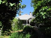
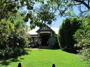
Aesthetic, Historical, Representative & Rarity Aldgate, a substantial single-storey, limestone and brick Federation Queen Anne style residence, has cultural heritage significance for the following reasons: • It is a fine example of the Federation Queen Anne style of architecture common in Perth's suburbs during the 1890s and 1900s; • It is enhanced by its formal approach, the building's close relationship to the paved terrace and orchestrated views west to the harbour and north-west to the Swan River, the place represents the scale and style of residences built on large, river facing lots in East Fremantle during the gold boom period; and • The place has scientific value for the extent and rarity in Western Australia of the original interior decorative treatments and the resource it provides for further study. The five additional houses and associated landscape have low significance. The additions and outbuildings have low significance. AESTHETIC SIGNIFICANCE: Aldgate has exceptional aesthetic value as a fine example of the Federation Queen Anne style. The place is enhanced by hand-painted ceiling murals, friezes and stencils to the interior of the residence. It retains almost all of the characteristic features of a dwelling of the type and period. HISTORIC SIGNIFICANCE: Aldgate has exceptional historic value. It is a reminder of a period when elevated locations on Preston Point Road and the immediate surroundings were desirable residential locations for the more affluent. Aldgate had a close association, for a comparatively short period, with Paul Strelitz. Paul's brother Richard established a trading company and was influential in international trade, diplomacy and local politics in Perth and Fremantle. SCIENTIFIC SIGNIFICANCE: The place has scientific value. The original interior decorative treatments are extensive and rare in Western Australia. The place is a resource that provides for further study. SOCIAL SIGNIFICANCE: Aldgate has exceptional social value. It is associated with a significant area of middle class Federation and Inter-war period development which contributes to the community's sense of place.
Federation Federation Bungalow w Queen Anne Influences No 7 Aldgate Place, Aldgate, is a single storey house constructed in limestone, tuck pointed brick and rendered brick with a hipped and gable corrugated iron roof. Aldgate is a very fine example of the Federation Queen Anne style. The place is enhanced by hand-painted ceiling murals, friezes and stencils to the interior of the residence. The front elevation is asymmetrically planned with a thrust bay and a part width return hip roofed verandah. The verandah is supported on timber posts with a decorative wrought iron frieze. The gable bay features a cartouche and a bay window. The bay window features a pair of double hung sash windows and hopper lights. There is a central door and hopper light flanked by sidelights and double hung sash windows. There is a diagonal corner bay with a pair of windows. A gable sits above the bay. There is a long, elevated approach to the residence. The aesthetic qualities of the place are enhanced with its relationship to the gardens, formal broad stone steps and Italianate balustrades. Although the content of the gardens is of little value. The roofscape features tall render capped chimneys. Walls are tuck pointed brick with rendered quoins. The place retains its form and most of its details. There are additions to the rear and out buildings to the north. The lot has been subdivided and several residences built to the front. These residences and Aldgate share a common road titled Aldgate Place. The place is consistent with the building pattern in the Precinct. The place plays an important role in the pattern of development of a middle class suburb.
Historic Theme: Demographic Settlement In September 1883 Stephen Henry Parker and James Morrison of Perth commenced subdivision of 65 acres of land to the north of Canning Road. The subdivision occurred at Swan Locations 63, 176, 219 and the south western portion of Swan Location 306. The subdivision included Preston Point Road, Alcester Gardens, Wolsely Gardens, Victoria Road, Alexandra Road, Parry Avenue, and Salvado Avenue. The Richmond Precinct was owned by Walter Easton and was named after the town of Richmond where Easton lived in England. In 1901 Easton’s sons subdivided Windsor Estate. New streets to the subdivision of the Windsor Estate were named after various members of the Easton family; Walter, Gill, Stratford and Morgan (later Osborne Road). Initially lot sizes were generous but sold at a slow rate. The initial development of the Richmond Precinct occurred at Canning Highway and Preston Point Road. Substantial residences were developed on these streets giving precedence to the future development of Richmond. The distinct architecture of Canning Highway and Preston Point Road distinguish Richmond from the surrounding area. By 1913 there were approximately 40 residences in the area between Preston Point Road and Alexandra Road. Osborne Road, Windsor Road and Gill Street had several buildings apiece by 1913. By 1931 approximately half the lots were developed. In 1921 Richmond Primary School was developed between Windsor and Osborne Road and several Inter-War residences were developed in the immediate area. In the 1930s the Workers’ Homes’ Board developed a number of weatherboard, asbestos, brick and tiled residences. Inter-War style front porches were preferred over Federation style full width verandahs. Redevelopments have occurred throughout the Richmond Precinct. Large lot sizes have allowed Richmond to be subject to the redevelopment of group and multiple housing. However, significant clusters of heritage dwellings remain throughout. Aldgate is significant as an example of residences built on large river facing lots for the more affluent of East Fremantle's citizens in the 1890s and early 1900s. The place is a reminder of a period when the elevated locations on Preston Point Road. The place and its immediate surroundings were desirable residential locations for the more affluent. Aldgate had a close association, for a comparatively short period, with Paul Strelitz. Paul's brother Richard established a trading company and was influential in international trade, diplomacy and local politics in Perth and Fremantle.
Integrity: Very High
Excellent
This information is provided voluntarily as a public service. The information provided is made available in good faith and is derived from sources believed to be reliable and accurate. However, the information is provided solely on the basis that readers will be responsible for making their own assessment of the matters discussed herein and are advised to verify all relevant representations, statements and information.
A large turn o1 the century house, significant for its architectural character of high gabled roofs and wide surrounding verandahs in the bungalow style, set in expansive grounds overlooking the river. Significant also as an example of the expression at that time in suburban housing of the opulence of the merchants who built the house.
A large residence set in extensive grounds, reduced in size in recent years. The house is built of brick and stone, with CGI roofs, ornate timber work to projecting gables , and cast iron lace decoration to verandah posts. A .curved Italianate terrace, with steps down to the gardens gives prominence to the front of the house. The house is characteristic or large houses in East Fremantle set on high ground with extensive views.
Builtc.1900 The house was originally owned by Mr Paul Strelitz, who with his brother Richard were Merchants and Shipping Agents in Fremantle and Kalgoorlie. Most notably they were agents for the German-Australian Steamship Company, shipping explosives, cement and wire for the expanding mining and rural industries in all parts of Western Australia at that time. They were also agents for the Alfred Nobel Hamburg Explosive Company Ltd, and held agencies and magazines all over the go1dfie1ds. Mr Richard Strelitz was Royal Consul for Denmark.
This information is provided voluntarily as a public service. The information provided is made available in good faith and is derived from sources believed to be reliable and accurate. However, the information is provided solely on the basis that readers will be responsible for making their own assessment of the matters discussed herein and are advised to verify all relevant representations, statements and information.
21 Alexandra Rd East Fremantle
East Fremantle
Metropolitan
| Type | Status | Date | Documents |
|---|---|---|---|
| Heritage List | Adopted | 17 Nov 2015 |
| Type | Status | Date | Documents |
|---|---|---|---|
| (no listings) |
| Type | Status | Date | Grading/Management | |
|---|---|---|---|---|
| Category | ||||
| Municipal Inventory | Adopted | 18 Nov 1997 | Category B | |
10319 Two Houses
Individual Building or Group
| Epoch | General | Specific |
|---|---|---|
| Original Use | RESIDENTIAL | Single storey residence |
| Present Use | RESIDENTIAL | Single storey residence |
| Style |
|---|
| Federation Bungalow |
This information is provided voluntarily as a public service. The information provided is made available in good faith and is derived from sources believed to be reliable and accurate. However, the information is provided solely on the basis that readers will be responsible for making their own assessment of the matters discussed herein and are advised to verify all relevant representations, statements and information.
Aesthetic & Representative STATEMENT OF SIGNIFICANCE No 21 Alexandra Road is a single storey house constructed in rendered brick with a corrugated iron roof. It has historic and aesthetic value for its contribution to Richmond's high concentration of predominantly Federation and Inter-War period houses and associated buildings. The place contributes to the local community’s sense of place. The place has considerable aesthetic value as a Federation Bungalow. The place retains a moderate to high degree of authenticity and a high degree of integrity. The carport and additions have no significance. AESTHETIC SIGNIFICANCE No 21 Alexandra Road has considerable aesthetic value as a Federation Bungalow. It retains most of the characteristic features of a dwelling of the type and period. HISTORIC SIGNIFICANCE No 21 Alexandra Road has some historic value. It was part of the suburban residential development associated with the expansion of East Fremantle and the subdivision of Stephen Henry Parker and James Morrison’s and then Walter Easton’s Estate from 1901. SOCIAL SIGNIFICANCE No 21 Alexandra Road has some social value. It is associated with a significant area of middle class Federation and Inter-War period development which contributes to the community's sense of place.
No 21 Alexandra Road is a single storey house constructed in rendered brick with a hipped corrugated iron roof. It is a fine expression of the Federation Bungalow style. It is asymmetrically composed with a thrust bay and a part width return hip roofed verandah. The verandah is supported on turned timber posts with post brackets and a decorative frieze. The verandah has been extended south to act as a carport. The thrust bay features a polygonal bay with double hung sash windows. There is a central door and hopper light flanked by side lights and a pair of double hung sash windows. The roofscape features a pair of rendered chimneys. The place retains its form and most of its details. There are additions to the rear. The place is consistent with the building pattern in the Precinct. The place plays an important role in the pattern of development of a middle class suburb.
Historic Theme: Demographic Settlement In September 1883 Stephen Henry Parker and James Morrison of Perth commenced subdivision of 65 acres of land to the north of Canning Road. The subdivision occurred at Swan Locations 63, 176, 219 and the south western portion of Swan Location 306. The subdivision included Preston Point Road, Alcester Gardens, Wolsely Gardens, Victoria Road, Alexandra Road, Parry Avenue, and Salvado Avenue. The Richmond Precinct was owned by Walter Easton and was named after the town of Richmond where Easton lived in England. In 1901 Easton’s sons subdivided Windsor Estate. New streets to the subdivision of the Windsor Estate were named after various members of the Easton family; Walter, Gill, Stratford and Morgan (later Osborne Road). Initially lot sizes were generous but sold at a slow rate. The initial development of the Richmond Precinct occurred at Canning Highway and Preston Point Road. Substantial residences were developed on these streets giving precedence to the future development of Richmond. The distinct architecture of Canning Highway and Preston Point Road distinguish Richmond from the surrounding area. By 1913 there were approximately 40 residences in the area between Preston Point Road and Alexandra Road. Osborne Road, Windsor Road and Gill Street had several buildings apiece by 1913. By 1931 approximately half the lots were developed. In 1921 Richmond Primary School was developed between Windsor and Osborne Road and several Inter-War residences were developed in the immediate area. In the 1930s the Workers’ Homes’ Board developed a number of weatherboard, asbestos, brick and tiled residences. Inter-War style front porches were preferred over Federation style full width verandahs. Redevelopments have occurred throughout the Richmond Precinct. Large lot sizes have allowed Richmond to be subject to the redevelopment of group and multiple housing. However, significant clusters of heritage dwellings remain throughout.
Integrity: High
Good
This information is provided voluntarily as a public service. The information provided is made available in good faith and is derived from sources believed to be reliable and accurate. However, the information is provided solely on the basis that readers will be responsible for making their own assessment of the matters discussed herein and are advised to verify all relevant representations, statements and information.
22 Alexandra Rd East Fremantle
East Fremantle
Metropolitan
| Type | Status | Date | Documents |
|---|---|---|---|
| Heritage List | Adopted | 17 Nov 2015 |
| Type | Status | Date | Documents |
|---|---|---|---|
| (no listings) |
| Type | Status | Date | Grading/Management | |
|---|---|---|---|---|
| Category | ||||
| Municipal Inventory | Adopted | 15 Aug 2006 | Category B | |
Individual Building or Group
| Epoch | General | Specific |
|---|---|---|
| Original Use | RESIDENTIAL | Single storey residence |
| Present Use | RESIDENTIAL | Single storey residence |
| Style |
|---|
| Federation Bungalow |
| Inter-War California Bungalow |
This information is provided voluntarily as a public service. The information provided is made available in good faith and is derived from sources believed to be reliable and accurate. However, the information is provided solely on the basis that readers will be responsible for making their own assessment of the matters discussed herein and are advised to verify all relevant representations, statements and information.
Aesthetic & Representative
PHYSICAL DESCRIPTION No 22 Alexandra Road is a single storey house constructed in limestone and rendered brick with a hipped and gable tiled roof. It is an expression of the Federation Bungalow style. It is asymmetrically composed with a thrust gable bay and a part width return skillion roofed verandah. The verandah terminates at the gable bay and is supported on Tuscan columns set over piers. A vertical timber balustrade spans between the piers. The gable bay features a pair of double hung sash windows under a tiled awning. The entry door is on the south elevation under the return verandah. It is unlikely that the place was rendered in the first instance. The roofscape features rendered chimneys. The place retains its form and most of its details. There are additions to the rear. The place is consistent with the building pattern in the Precinct. The place plays an important role in the pattern of development of a middle class suburb.
Historic Theme: Demographic Settlement In September 1883 Stephen Henry Parker and James Morrison of Perth commenced subdivision of 65 acres of land to the north of Canning Road. The subdivision occurred at Swan Locations 63, 176, 219 and the south western portion of Swan Location 306. The subdivision included Preston Point Road, Alcester Gardens, Wolsely Gardens, Victoria Road, Alexandra Road, Parry Avenue, and Salvado Avenue. The Richmond Precinct was owned by Walter Easton and was named after the town of Richmond where Easton lived in England. In 1901 Easton’s sons subdivided Windsor Estate. New streets to the subdivision of the Windsor Estate were named after various members of the Easton family; Walter, Gill, Stratford and Morgan (later Osborne Road). Initially lot sizes were generous but sold at a slow rate. The initial development of the Richmond Precinct occurred at Canning Highway and Preston Point Road. Substantial residences were developed on these streets giving precedence to the future development of Richmond. The distinct architecture of Canning Highway and Preston Point Road distinguish Richmond from the surrounding area. By 1913 there were approximately 40 residences in the area between Preston Point Road and Alexandra Road. Osborne Road, Windsor Road and Gill Street had several buildings apiece by 1913. By 1931 approximately half the lots were developed. In 1921 Richmond Primary School was developed between Windsor and Osborne Road and several Inter-War residences were developed in the immediate area. In the 1930s the Workers’ Homes’ Board developed a number of weatherboard, asbestos, brick and tiled residences. Inter-War style front porches were preferred over Federation style full width verandahs. Redevelopments have occurred throughout the Richmond Precinct. Large lot sizes have allowed Richmond to be subject to the redevelopment of group and multiple housing. However, significant clusters of heritage dwellings remain throughout.
Integrity: Moderate
Good
This information is provided voluntarily as a public service. The information provided is made available in good faith and is derived from sources believed to be reliable and accurate. However, the information is provided solely on the basis that readers will be responsible for making their own assessment of the matters discussed herein and are advised to verify all relevant representations, statements and information.
23 Alexandra Rd East Fremantle
East Fremantle
Metropolitan
| Type | Status | Date | Documents |
|---|---|---|---|
| Heritage List | Adopted | 17 Nov 2015 |
| Type | Status | Date | Documents |
|---|---|---|---|
| (no listings) |
| Type | Status | Date | Grading/Management | |
|---|---|---|---|---|
| Category | ||||
| Municipal Inventory | Adopted | 18 Nov 1997 | Category B | |
10319 Two Houses
Individual Building or Group
| Epoch | General | Specific |
|---|---|---|
| Present Use | RESIDENTIAL | Single storey residence |
| Original Use | RESIDENTIAL | Single storey residence |
| Style |
|---|
| Federation Carpenter Gothic |
This information is provided voluntarily as a public service. The information provided is made available in good faith and is derived from sources believed to be reliable and accurate. However, the information is provided solely on the basis that readers will be responsible for making their own assessment of the matters discussed herein and are advised to verify all relevant representations, statements and information.
Aesthetic & Representative STATEMENT OF SIGNIFICANCE No 23 Alexandra Road is a single storey house constructed in timber framing and weatherboard cladding with a corrugated iron roof. It has historic and aesthetic value for its contribution to Richmond's high concentration of predominantly Federation and Inter-War period houses and associated buildings. The place contributes to the local community’s sense of place. The place has considerable aesthetic value as a Federation Bungalow. The place retains a moderate to high degree of authenticity and a high degree of integrity. The additions to the rear have no significance. AESTHETIC SIGNIFICANCE No 23 Alexandra Road has considerable aesthetic value as a Federation Bungalow. It retains most of the characteristic features of a dwelling of the type and period. HISTORIC SIGNIFICANCE No 23 Alexandra Road has some historic value. It was part of the suburban residential development associated with the expansion of East Fremantle and the subdivision of Stephen Henry Parker and James Morrison’s and then Walter Easton’s Estate from 1901. SOCIAL SIGNIFICANCE No 23 Alexandra Road has some social value. It is associated with a significant area of middle class Federation and Inter-War period development which contributes to the community's sense of place.
No 23 Alexandra Road is a single storey house constructed in timber framing and weatherboard cladding with a hipped and gable corrugated iron roof. It is a fine expression of the Federation Bungalow style. It is asymmetrically composed with a thrust gable bay and a part width return bull-nosed roofed verandah. The verandah is supported on turned timber posts with brackets and a frieze. The verandah terminates at the thrust bay. The gable bay features a window under a sunhood. There is a central door and hopper light flanked by sidelights and a window. The windows are double hung sashes flanked by sidelights. The place retains its form and most of its details. There are additions to the rear. The place is consistent with the building pattern in the Precinct. The place plays an important role in the pattern of development of a middle class suburb.
Historic Theme: Demographic Settlement In September 1883 Stephen Henry Parker and James Morrison of Perth commenced subdivision of 65 acres of land to the north of Canning Road. The subdivision occurred at Swan Locations 63, 176, 219 and the south western portion of Swan Location 306. The subdivision included Preston Point Road, Alcester Gardens, Wolsely Gardens, Victoria Road, Alexandra Road, Parry Avenue, and Salvado Avenue. The Richmond Precinct was owned by Walter Easton and was named after the town of Richmond where Easton lived in England. In 1901 Easton’s sons subdivided Windsor Estate. New streets to the subdivision of the Windsor Estate were named after various members of the Easton family; Walter, Gill, Stratford and Morgan (later Osborne Road). Initially lot sizes were generous but sold at a slow rate. The initial development of the Richmond Precinct occurred at Canning Highway and Preston Point Road. Substantial residences were developed on these streets giving precedence to the future development of Richmond. The distinct architecture of Canning Highway and Preston Point Road distinguish Richmond from the surrounding area. By 1913 there were approximately 40 residences in the area between Preston Point Road and Alexandra Road. Osborne Road, Windsor Road and Gill Street had several buildings apiece by 1913. By 1931 approximately half the lots were developed. In 1921 Richmond Primary School was developed between Windsor and Osborne Road and several Inter-War residences were developed in the immediate area. In the 1930s the Workers’ Homes’ Board developed a number of weatherboard, asbestos, brick and tiled residences. Inter-War style front porches were preferred over Federation style full width verandahs. Redevelopments have occurred throughout the Richmond Precinct. Large lot sizes have allowed Richmond to be subject to the redevelopment of group and multiple housing. However, significant clusters of heritage dwellings remain throughout.
Integrity: High
Good
This information is provided voluntarily as a public service. The information provided is made available in good faith and is derived from sources believed to be reliable and accurate. However, the information is provided solely on the basis that readers will be responsible for making their own assessment of the matters discussed herein and are advised to verify all relevant representations, statements and information.
24 Alexandra Rd East Fremantle
East Fremantle
Metropolitan
| Type | Status | Date | Documents |
|---|---|---|---|
| Heritage List | Adopted | 17 Nov 2015 |
| Type | Status | Date | Documents |
|---|---|---|---|
| (no listings) |
| Type | Status | Date | Grading/Management | |
|---|---|---|---|---|
| Category | ||||
| Municipal Inventory | Adopted | 15 Aug 2006 | Category B | |
Individual Building or Group
| Epoch | General | Specific |
|---|---|---|
| Present Use | RESIDENTIAL | Single storey residence |
| Original Use | RESIDENTIAL | Single storey residence |
| Style |
|---|
| Federation Bungalow |
This information is provided voluntarily as a public service. The information provided is made available in good faith and is derived from sources believed to be reliable and accurate. However, the information is provided solely on the basis that readers will be responsible for making their own assessment of the matters discussed herein and are advised to verify all relevant representations, statements and information.
Aesthetic & Representative STATEMENT OF SIGNIFICANCE No 24 Alexandra Road is a single storey house constructed in brick and rendered brick with a corrugated iron roof. It has historic and aesthetic value for its contribution to Richmond's high concentration of predominantly Federation and Inter-War period houses and associated buildings. The place contributes to the local community’s sense of place. The place has considerable aesthetic value as a Federation Bungalow. The place retains a moderate degree of authenticity and a high degree of integrity. The additions have no significance. AESTHETIC SIGNIFICANCE No 24 Alexandra Road has considerable aesthetic value as a Federation Bungalow. It retains most of the characteristic features of a dwelling of the type and period. HISTORIC SIGNIFICANCE: No 24 Alexandra Road has considerable historic value. It was part of the suburban residential development associated with the expansion of East Fremantle and the subdivision of Stephen Henry Parker and James Morrison’s and then Walter Easton’s Estate from 1901. SOCIAL SIGNIFICANCE No 24 Alexandra Road has considerable social value. It is associated with a significant area of middle class Federation and Inter-War period development which contributes to the community's sense of place.
No 24 Alexandra Road is a single storey house constructed in brick and rendered brick with an ‘M’ format corrugated iron roof. It is an expression of the Federation Bungalow style. It is asymmetrically composed with a gable bay and a full width return broken back roofed verandah. The verandah extends over the gable bay and is supported on steel posts. A steel balustrade spans between the posts. There is a central door flanked by windows. The verandah has been extended south and modified to fit a basement level garage. The roofscape features a rendered chimney. There are rendered quoins to the original openings. The place retains its form and most of its details. The gable has been simplified and verandah detailing lost. There are additions to the rear. The place is consistent with the building pattern in the Precinct. The place plays an important role in the pattern of development of a middle class suburb.
Historic Theme: Demographic Settlement In September 1883 Stephen Henry Parker and James Morrison of Perth commenced subdivision of 65 acres of land to the north of Canning Road. The subdivision occurred at Swan Locations 63, 176, 219 and the south western portion of Swan Location 306. The subdivision included Preston Point Road, Alcester Gardens, Wolsely Gardens, Victoria Road, Alexandra Road, Parry Avenue, and Salvado Avenue. The Richmond Precinct was owned by Walter Easton and was named after the town of Richmond where Easton lived in England. In 1901 Easton’s sons subdivided Windsor Estate. New streets to the subdivision of the Windsor Estate were named after various members of the Easton family; Walter, Gill, Stratford and Morgan (later Osborne Road). Initially lot sizes were generous but sold at a slow rate. The initial development of the Richmond Precinct occurred at Canning Highway and Preston Point Road. Substantial residences were developed on these streets giving precedence to the future development of Richmond. The distinct architecture of Canning Highway and Preston Point Road distinguish Richmond from the surrounding area. By 1913 there were approximately 40 residences in the area between Preston Point Road and Alexandra Road. Osborne Road, Windsor Road and Gill Street had several buildings apiece by 1913. By 1931 approximately half the lots were developed. In 1921 Richmond Primary School was developed between Windsor and Osborne Road and several Inter-War residences were developed in the immediate area. In the 1930s the Workers’ Homes’ Board developed a number of weatherboard, asbestos, brick and tiled residences. Inter-War style front porches were preferred over Federation style full width verandahs. Redevelopments have occurred throughout the Richmond Precinct. Large lot sizes have allowed Richmond to be subject to the redevelopment of group and multiple housing. However, significant clusters of heritage dwellings remain throughout.
Integrity: High
Fair
This information is provided voluntarily as a public service. The information provided is made available in good faith and is derived from sources believed to be reliable and accurate. However, the information is provided solely on the basis that readers will be responsible for making their own assessment of the matters discussed herein and are advised to verify all relevant representations, statements and information.
27 Alexandra Rd East Fremantle
East Fremantle
Metropolitan
| Type | Status | Date | Documents |
|---|---|---|---|
| Heritage List | Adopted | 17 Nov 2015 |
| Type | Status | Date | Documents |
|---|---|---|---|
| (no listings) |
| Type | Status | Date | Grading/Management | |
|---|---|---|---|---|
| Category | ||||
| Municipal Inventory | Adopted | 15 Aug 2006 | Category A | |
Individual Building or Group
| Epoch | General | Specific |
|---|---|---|
| Original Use | RESIDENTIAL | Single storey residence |
| Present Use | RESIDENTIAL | Single storey residence |
| Style |
|---|
| Federation Filigree |
This information is provided voluntarily as a public service. The information provided is made available in good faith and is derived from sources believed to be reliable and accurate. However, the information is provided solely on the basis that readers will be responsible for making their own assessment of the matters discussed herein and are advised to verify all relevant representations, statements and information.
Aesthetic & Representative STATEMENT OF SIGNIFICANCE No 27 Alexandra Road is a single storey house constructed in tuck pointed brick and rendered brick with a corrugated iron roof. It has historic and aesthetic value for its contribution to Richmond's high concentration of predominantly Federation and Inter-War period houses and associated buildings. The place contributes to the local community’s sense of place. The place has exceptional aesthetic value as a Federation Bungalow. The place retains a moderate to high degree of authenticity and a high degree of integrity. The additions have no significance. AESTHETIC SIGNIFICANCE No 27 Alexandra Road has exceptional aesthetic value as a Federation Bungalow. It retains most of the characteristic features of a dwelling of the type and period. HISTORIC SIGNIFICANCE No 27 Alexandra Road has considerable historic value. It was part of the suburban residential development associated with the expansion of East Fremantle and the subdivision of Stephen Henry Parker and James Morrison’s and then Walter Easton’s Estate from 1901. SOCIAL SIGNIFICANCE No 27 Alexandra Road has considerable social value. It is associated with a significant area of middle class Federation and Inter-War period development which contributes to the community's sense of place.
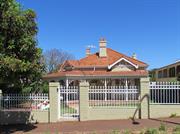
No 27 Alexandra Road is a single storey house constructed in tuck pointed brick and rendered brick with a hipped and gable corrugated iron roof. It is a very fine expression of the Federation Filigree style. It is symmetrically composed with a full width return hip roofed verandah. The verandah is supported on turned timber posts with post brackets. A vertical timber balustrade spans between the posts. A gable roofed porch is located centrally over the verandah. The gable has timber filigree detailing and a jettied gable. There is a central door flanked by pairs of French double hung sash windows. There are rendered string courses. The roofscape features several tall, part rendered chimneys. The place retains its form and most of its details. There are additions to the rear. The place is consistent with the building pattern in the Precinct. The place plays an important role in the pattern of development of a middle class suburb. HISTORIC THEME Demographic Settlements - Residential Subdivision CONSTRUCTION MATERIALS Walls – Tuck pointed brick and rendered brick Roof – Corrugated iron sheeting PHYSICAL SETTING The residence is situated on a sloping site with a brick wall and steel palisade fence on the lot boundary.
Historic Theme: Demographic Settlement In September 1883 Stephen Henry Parker and James Morrison of Perth commenced subdivision of 65 acres of land to the north of Canning Road. The subdivision occurred at Swan Locations 63, 176, 219 and the south western portion of Swan Location 306. The subdivision included Preston Point Road, Alcester Gardens, Wolsely Gardens, Victoria Road, Alexandra Road, Parry Avenue, and Salvado Avenue. The Richmond Precinct was owned by Walter Easton and was named after the town of Richmond where Easton lived in England. In 1901 Easton’s sons subdivided Windsor Estate. New streets to the subdivision of the Windsor Estate were named after various members of the Easton family; Walter, Gill, Stratford and Morgan (later Osborne Road). Initially lot sizes were generous but sold at a slow rate. The initial development of the Richmond Precinct occurred at Canning Highway and Preston Point Road. Substantial residences were developed on these streets giving precedence to the future development of Richmond. The distinct architecture of Canning Highway and Preston Point Road distinguish Richmond from the surrounding area. By 1913 there were approximately 40 residences in the area between Preston Point Road and Alexandra Road. Osborne Road, Windsor Road and Gill Street had several buildings apiece by 1913. By 1931 approximately half the lots were developed. In 1921 Richmond Primary School was developed between Windsor and Osborne Road and several Inter-War residences were developed in the immediate area. In the 1930s the Workers’ Homes’ Board developed a number of weatherboard, asbestos, brick and tiled residences. Inter-War style front porches were preferred over Federation style full width verandahs. Redevelopments have occurred throughout the Richmond Precinct. Large lot sizes have allowed Richmond to be subject to the redevelopment of group and multiple housing. However, significant clusters of heritage dwellings remain throughout.
Good
This information is provided voluntarily as a public service. The information provided is made available in good faith and is derived from sources believed to be reliable and accurate. However, the information is provided solely on the basis that readers will be responsible for making their own assessment of the matters discussed herein and are advised to verify all relevant representations, statements and information.
28 Alexandra Rd East Fremantle
East Fremantle
Metropolitan
| Type | Status | Date | Documents |
|---|---|---|---|
| Heritage List | Adopted | 17 Nov 2015 |
| Type | Status | Date | Documents |
|---|---|---|---|
| (no listings) |
| Type | Status | Date | Grading/Management | |
|---|---|---|---|---|
| Category | ||||
| Municipal Inventory | Adopted | 15 Aug 2006 | Category B | |
| Aboriginal Heritage Sites Register | Adopted | 15 Aug 2006 | ||
Individual Building or Group
| Epoch | General | Specific |
|---|---|---|
| Original Use | RESIDENTIAL | Single storey residence |
| Present Use | RESIDENTIAL | Single storey residence |
| Style |
|---|
| Federation Arts and Crafts |
This information is provided voluntarily as a public service. The information provided is made available in good faith and is derived from sources believed to be reliable and accurate. However, the information is provided solely on the basis that readers will be responsible for making their own assessment of the matters discussed herein and are advised to verify all relevant representations, statements and information.
Aesthetic & Representative STATEMENT OF SIGNIFICANCE No 28 Alexandra Road is a single storey house constructed in brick and rendered brick with a corrugated iron roof. It has historic and aesthetic value for its contribution to Richmond's high concentration of predominantly Federation and Inter-War period houses and associated buildings. The place contributes to the local community’s sense of place. The place has considerable aesthetic value as a Federation Bungalow. The place retains a moderate to high degree of authenticity and a high degree of integrity. The additions and houses to the rear have no significance. AESTHETIC SIGNIFICANCE No 28 Alexandra Road has considerable aesthetic value as a Federation Bungalow. It retains most of the characteristic features of a dwelling of the type and period. HISTORIC SIGNIFICANCE No 28 Alexandra Road has some historic value. It was part of the suburban residential development associated with the expansion of East Fremantle and the subdivision of Stephen Henry Parker and James Morrison’s and then Walter Easton’s Estate from 1901. SOCIAL SIGNIFICANCE No 28 Alexandra Road has some social value. It is associated with a significant area of middle class Federation and Inter-War period development which contributes to the community's sense of place.
No 28 Alexandra Road is a single storey house constructed in rendered brick with a hipped and gable corrugated iron roof. It is a fine expression of the Federation Bungalow style. It is symmetrically composed with a full width return verandah. The verandah is supported on turned timber posts with valance boards. A half timbered gable is located centrally over the verandah to mark the entry. There is a central door and hopper light flanked by pairs of French double hung sash windows. The roofscape features tall rendered capped chimneys. The place retains its form and most of its details. There are additions to the rear. The lot has been subdivided and amalgamated. Residences have been built to the rear. The place is consistent with the building pattern in the Precinct. The place plays an important role in the pattern of development of a middle class suburb. HISTORIC THEME Demographic Settlements - Residential Subdivision CONSTRUCTION MATERIALS Walls – Rendered brick Roof – Corrugated iron sheeting PHYSICAL SETTING The residence is situated on a sloping site with a limestone wall and steel palisade fence on the lot boundary.
Historic Theme: Demographic Settlement In September 1883 Stephen Henry Parker and James Morrison of Perth commenced subdivision of 65 acres of land to the north of Canning Road. The subdivision occurred at Swan Locations 63, 176, 219 and the south western portion of Swan Location 306. The subdivision included Preston Point Road, Alcester Gardens, Wolsely Gardens, Victoria Road, Alexandra Road, Parry Avenue, and Salvado Avenue. The Richmond Precinct was owned by Walter Easton and was named after the town of Richmond where Easton lived in England. In 1901 Easton’s sons subdivided Windsor Estate. New streets to the subdivision of the Windsor Estate were named after various members of the Easton family; Walter, Gill, Stratford and Morgan (later Osborne Road). Initially lot sizes were generous but sold at a slow rate. The initial development of the Richmond Precinct occurred at Canning Highway and Preston Point Road. Substantial residences were developed on these streets giving precedence to the future development of Richmond. The distinct architecture of Canning Highway and Preston Point Road distinguish Richmond from the surrounding area. By 1913 there were approximately 40 residences in the area between Preston Point Road and Alexandra Road. Osborne Road, Windsor Road and Gill Street had several buildings apiece by 1913. By 1931 approximately half the lots were developed. In 1921 Richmond Primary School was developed between Windsor and Osborne Road and several Inter-War residences were developed in the immediate area. In the 1930s the Workers’ Homes’ Board developed a number of weatherboard, asbestos, brick and tiled residences. Inter-War style front porches were preferred over Federation style full width verandahs. Redevelopments have occurred throughout the Richmond Precinct. Large lot sizes have allowed Richmond to be subject to the redevelopment of group and multiple housing. However, significant clusters of heritage dwellings remain throughout.
Integrity: Moderate
Good
| Reserve | Lot/Location | Plan/Diagram | Vol/Folio |
|---|---|---|---|
| 20 | D59349 | 1567 |
This information is provided voluntarily as a public service. The information provided is made available in good faith and is derived from sources believed to be reliable and accurate. However, the information is provided solely on the basis that readers will be responsible for making their own assessment of the matters discussed herein and are advised to verify all relevant representations, statements and information.
29 Alexandra Rd East Fremantle
East Fremantle
Metropolitan
| Type | Status | Date | Documents |
|---|---|---|---|
| Heritage List | Adopted | 17 Nov 2015 |
| Type | Status | Date | Documents |
|---|---|---|---|
| (no listings) |
| Type | Status | Date | Grading/Management | |
|---|---|---|---|---|
| Category | ||||
| Municipal Inventory | Adopted | 18 Nov 1997 | Category B | |
10320 Two Houses
Individual Building or Group
| Epoch | General | Specific |
|---|---|---|
| Original Use | RESIDENTIAL | Single storey residence |
| Present Use | RESIDENTIAL | Single storey residence |
| Style |
|---|
| Federation Academic Classical |
This information is provided voluntarily as a public service. The information provided is made available in good faith and is derived from sources believed to be reliable and accurate. However, the information is provided solely on the basis that readers will be responsible for making their own assessment of the matters discussed herein and are advised to verify all relevant representations, statements and information.
Aesthetic & Representative STATEMENT OF SIGNIFICANCE No 29 Alexandra Road is a single storey house constructed in brick and rendered brick with a corrugated iron roof. It has historic and aesthetic value for its contribution to Richmond's high concentration of predominantly Federation and Inter-War period houses and associated buildings. The place contributes to the local community’s sense of place. The place has considerable aesthetic value as a Federation Queen Anne style house. The place retains a moderate to high degree of authenticity and a high degree of integrity. The additions have no significance. AESTHETIC SIGNIFICANCE No 29 Alexandra Road has considerable aesthetic value as a Federation Queen Anne style house. It retains most of the characteristic features of a dwelling of the type and period. HISTORIC SIGNIFICANCE No 29 Alexandra Road has some historic value. It was part of the suburban residential development associated with the expansion of East Fremantle and the subdivision of Stephen Henry Parker and James Morrison’s and then Walter Easton’s Estate from 1901. SOCIAL SIGNIFICANCE No 29 Alexandra Road has some social value. It is associated with a significant area of middle class Federation and Inter-War period development which contributes to the community's sense of place.
No 29 Alexandra Road is a single storey house constructed in brick and rendered brick with a hipped and gable tiled roof. It is a fine expression of the Federation Queen Anne style. It is asymmetrically composed with a thrust gable bay and a full width return hip roofed verandah supported on turned timber posts with timber fretwork. There is a gable bay to the corner of the house. Both gable bays feature sets of double hung sash windows. The entry door is located on the south elevation under the return verandah. The roofscape features tall rendered chimneys. There are rendered quoins and sills are decorative. The place retains its form and most of its details. There are additions to the rear. The place is consistent with the building pattern in the Precinct. The place plays an important role in the pattern of development of a middle class suburb. CONSTRUCTION MATERIALS Walls – Brick and rendered brick Roof – Corrugated iron sheeting PHYSICAL SETTING The residence is situated on a sloping site with a painted brick wall and steel palisade fence on the lot boundary.
Historic Theme: Demographic Settlement In September 1883 Stephen Henry Parker and James Morrison of Perth commenced subdivision of 65 acres of land to the north of Canning Road. The subdivision occurred at Swan Locations 63, 176, 219 and the south western portion of Swan Location 306. The subdivision included Preston Point Road, Alcester Gardens, Wolsely Gardens, Victoria Road, Alexandra Road, Parry Avenue, and Salvado Avenue. The Richmond Precinct was owned by Walter Easton and was named after the town of Richmond where Easton lived in England. In 1901 Easton’s sons subdivided Windsor Estate. New streets to the subdivision of the Windsor Estate were named after various members of the Easton family; Walter, Gill, Stratford and Morgan (later Osborne Road). Initially lot sizes were generous but sold at a slow rate. The initial development of the Richmond Precinct occurred at Canning Highway and Preston Point Road. Substantial residences were developed on these streets giving precedence to the future development of Richmond. The distinct architecture of Canning Highway and Preston Point Road distinguish Richmond from the surrounding area. By 1913 there were approximately 40 residences in the area between Preston Point Road and Alexandra Road. Osborne Road, Windsor Road and Gill Street had several buildings apiece by 1913. By 1931 approximately half the lots were developed. In 1921 Richmond Primary School was developed between Windsor and Osborne Road and several Inter-War residences were developed in the immediate area. In the 1930s the Workers’ Homes’ Board developed a number of weatherboard, asbestos, brick and tiled residences. Inter-War style front porches were preferred over Federation style full width verandahs. Redevelopments have occurred throughout the Richmond Precinct. Large lot sizes have allowed Richmond to be subject to the redevelopment of group and multiple housing. However, significant clusters of heritage dwellings remain throughout. HISTORIC THEME Demographic Settlements - Residential Subdivision
Integrity: High
Good
This information is provided voluntarily as a public service. The information provided is made available in good faith and is derived from sources believed to be reliable and accurate. However, the information is provided solely on the basis that readers will be responsible for making their own assessment of the matters discussed herein and are advised to verify all relevant representations, statements and information.
31 Alexandra Rd East Fremantle
East Fremantle
Metropolitan
| Type | Status | Date | Documents |
|---|---|---|---|
| Heritage List | Adopted | 17 Nov 2015 |
| Type | Status | Date | Documents |
|---|---|---|---|
| (no listings) |
| Type | Status | Date | Grading/Management | |
|---|---|---|---|---|
| Category | ||||
| Municipal Inventory | Adopted | 15 Aug 2006 | Category B | |
Individual Building or Group
| Epoch | General | Specific |
|---|---|---|
| Original Use | RESIDENTIAL | Single storey residence |
| Present Use | RESIDENTIAL | Single storey residence |
| Style |
|---|
| Federation Bungalow |
This information is provided voluntarily as a public service. The information provided is made available in good faith and is derived from sources believed to be reliable and accurate. However, the information is provided solely on the basis that readers will be responsible for making their own assessment of the matters discussed herein and are advised to verify all relevant representations, statements and information.
Aesthetic & Representative STATEMENT OF SIGNIFICANCE No 31 Alexandra Road is a single storey house constructed in limestone and brick with a corrugated iron roof. It has historic and aesthetic value for its contribution to Richmond's high concentration of predominantly Federation and Inter-War period houses and associated buildings. The place contributes to the local community’s sense of place. The place has considerable aesthetic value as a Federation Bungalow. The place retains a moderate to high degree of authenticity and a high degree of integrity. The additions have no significance. AESTHETIC SIGNIFICANCE No 31 Alexandra Road has considerable aesthetic value as a Federation Bungalow. It retains most of the characteristic features of a dwelling of the type and period. HISTORIC SIGNIFICANCE No 31 Alexandra Road has some historic value. It was part of the suburban residential development associated with the expansion of East Fremantle and the subdivision of Stephen Henry Parker and James Morrison’s and then Walter Easton’s Estate from 1901. SOCIAL SIGNIFICANCE No 31 Alexandra Road has some social value. It is associated with a significant area of middle class Federation and Inter-War period development which contributes to the community's sense of place.
No 31 Alexandra Road is a single storey house constructed in limestone and brick with a hipped and gable corrugated iron roof. It is a fine expression of the Federation Bungalow style. It is asymmetrically composed with a full width return hip roofed verandah. The verandah is supported on turned timber posts with post brackets. At the southern end of the verandah there is a set of steps and a gabled entry. The gable features timber fretwork including what appears to be the initials D L. A new front door has been constructed to the eastern end of the return verandah. The front facade features bay windows with French double hung sashes. The roofscape features tall tuck pointed chimneys. The place retains its form and most of its details. There are additions to the rear. The place is consistent with the building pattern in the Precinct. The place plays an important role in the pattern of development of a middle class suburb. CONSTRUCTION MATERIALS Walls – Limestone and brick Roof – Corrugated iron sheeting PHYSICAL SETTING The residence is situated on a sloping site with a limestone wall on the lot boundary.
Historic Theme: Demographic Settlement In September 1883 Stephen Henry Parker and James Morrison of Perth commenced subdivision of 65 acres of land to the north of Canning Road. The subdivision occurred at Swan Locations 63, 176, 219 and the south western portion of Swan Location 306. The subdivision included Preston Point Road, Alcester Gardens, Wolsely Gardens, Victoria Road, Alexandra Road, Parry Avenue, and Salvado Avenue. The Richmond Precinct was owned by Walter Easton and was named after the town of Richmond where Easton lived in England. In 1901 Easton’s sons subdivided Windsor Estate. New streets to the subdivision of the Windsor Estate were named after various members of the Easton family; Walter, Gill, Stratford and Morgan (later Osborne Road). Initially lot sizes were generous but sold at a slow rate. The initial development of the Richmond Precinct occurred at Canning Highway and Preston Point Road. Substantial residences were developed on these streets giving precedence to the future development of Richmond. The distinct architecture of Canning Highway and Preston Point Road distinguish Richmond from the surrounding area. By 1913 there were approximately 40 residences in the area between Preston Point Road and Alexandra Road. Osborne Road, Windsor Road and Gill Street had several buildings apiece by 1913. By 1931 approximately half the lots were developed. In 1921 Richmond Primary School was developed between Windsor and Osborne Road and several Inter-War residences were developed in the immediate area. In the 1930s the Workers’ Homes’ Board developed a number of weatherboard, asbestos, brick and tiled residences. Inter-War style front porches were preferred over Federation style full width verandahs. Redevelopments have occurred throughout the Richmond Precinct. Large lot sizes have allowed Richmond to be subject to the redevelopment of group and multiple housing. However, significant clusters of heritage dwellings remain throughout. HISTORIC THEME Demographic Settlements - Residential Subdivision
Integrity: Very High
Fair
This information is provided voluntarily as a public service. The information provided is made available in good faith and is derived from sources believed to be reliable and accurate. However, the information is provided solely on the basis that readers will be responsible for making their own assessment of the matters discussed herein and are advised to verify all relevant representations, statements and information.
32 Alexandra Rd East Fremantle
East Fremantle
Metropolitan
| Type | Status | Date | Documents |
|---|---|---|---|
| Heritage List | Adopted | 17 Nov 2015 |
| Type | Status | Date | Documents |
|---|---|---|---|
| (no listings) |
| Type | Status | Date | Grading/Management | |
|---|---|---|---|---|
| Category | ||||
| Municipal Inventory | Adopted | 15 Aug 2006 | Category A | |
Individual Building or Group
| Epoch | General | Specific |
|---|---|---|
| Original Use | RESIDENTIAL | Single storey residence |
| Present Use | RESIDENTIAL | Single storey residence |
| Style |
|---|
| Federation Bungalow |
This information is provided voluntarily as a public service. The information provided is made available in good faith and is derived from sources believed to be reliable and accurate. However, the information is provided solely on the basis that readers will be responsible for making their own assessment of the matters discussed herein and are advised to verify all relevant representations, statements and information.
Aesthetic & Representative STATEMENT OF SIGNIFICANCE No 32 Alexandra Road is a single storey house constructed in limestone and brick with a corrugated iron roof. It has historic and aesthetic value for its contribution to Richmond's high concentration of predominantly Federation and Inter-War period houses and associated buildings. The place contributes to the local community’s sense of place. The place has exceptional aesthetic value as a Federation Bungalow. The place retains a moderate to high degree of authenticity and a high degree of integrity. The additions have little significance. AESTHETIC SIGNIFICANCE No 32 Alexandra Road has exceptional aesthetic value as a Federation Bungalow. It retains most of the characteristic features of a dwelling of the type and period. HISTORIC SIGNIFICANCE No 32 Alexandra Road has considerable historic value. It was part of the suburban residential development associated with the expansion of East Fremantle and the subdivision of Stephen Henry Parker and James Morrison’s and then Walter Easton’s Estate from 1901. SOCIAL SIGNIFICANCE No 32 Alexandra Road has considerable social value. It is associated with a significant area of middle class Federation and Inter-War period development which contributes to the community's sense of place.
No 32 Alexandra Road is a single storey house constructed in limestone and brick with a hipped and gable corrugated iron roof. It is a fine expression of the Federation Bungalow style. It is asymmetrically composed with a thrust gable bay and a full width return hip roofed verandah. The verandah is supported on turned timber posts with post brackets. A vertical timber balustrade spans between the posts. The half timbered gable bay features a bay window with a pair of double hung sashes. At the southern end of the verandah there is a set of steps leading down to the garden. The entrance is located on the south elevation under the return verandah. Windows are single pane double hung sashes. Particular features of the house include its roofscape, with tall jettied half-timbered gables and chimneys with rendered caps. The place retains its form and most of its details. There are additions to the rear and side of the house. A garage has been built to the south. The place is consistent with the building pattern in the Precinct. The place plays an important role in the pattern of development of a middle class suburb. CONSTRUCTION MATERIALS Walls – Limestone and brick Roof – Corrugated iron sheeting PHYSICAL SETTING The residence is situated on a sloping site with a limestone wall and steel palisade fence on the lot boundary.
Historic Theme: Demographic Settlement In September 1883 Stephen Henry Parker and James Morrison of Perth commenced subdivision of 65 acres of land to the north of Canning Road. The subdivision occurred at Swan Locations 63, 176, 219 and the south western portion of Swan Location 306. The subdivision included Preston Point Road, Alcester Gardens, Wolsely Gardens, Victoria Road, Alexandra Road, Parry Avenue, and Salvado Avenue. The Richmond Precinct was owned by Walter Easton and was named after the town of Richmond where Easton lived in England. In 1901 Easton’s sons subdivided Windsor Estate. New streets to the subdivision of the Windsor Estate were named after various members of the Easton family; Walter, Gill, Stratford and Morgan (later Osborne Road). Initially lot sizes were generous but sold at a slow rate. The initial development of the Richmond Precinct occurred at Canning Highway and Preston Point Road. Substantial residences were developed on these streets giving precedence to the future development of Richmond. The distinct architecture of Canning Highway and Preston Point Road distinguish Richmond from the surrounding area. By 1913 there were approximately 40 residences in the area between Preston Point Road and Alexandra Road. Osborne Road, Windsor Road and Gill Street had several buildings apiece by 1913. By 1931 approximately half the lots were developed. In 1921 Richmond Primary School was developed between Windsor and Osborne Road and several Inter-War residences were developed in the immediate area. In the 1930s the Workers’ Homes’ Board developed a number of weatherboard, asbestos, brick and tiled residences. Inter-War style front porches were preferred over Federation style full width verandahs. Redevelopments have occurred throughout the Richmond Precinct. Large lot sizes have allowed Richmond to be subject to the redevelopment of group and multiple housing. However, significant clusters of heritage dwellings remain throughout.
Integrity: High
Excellent
This information is provided voluntarily as a public service. The information provided is made available in good faith and is derived from sources believed to be reliable and accurate. However, the information is provided solely on the basis that readers will be responsible for making their own assessment of the matters discussed herein and are advised to verify all relevant representations, statements and information.
33 Alexandra Rd East Fremantle
East Fremantle
Metropolitan
| Type | Status | Date | Documents |
|---|---|---|---|
| Heritage List | Adopted | 17 Nov 2015 |
| Type | Status | Date | Documents |
|---|---|---|---|
| (no listings) |
| Type | Status | Date | Grading/Management | |
|---|---|---|---|---|
| Category | ||||
| Municipal Inventory | Adopted | 18 Nov 1997 | Category A | |
10320 Two Houses
Individual Building or Group
| Epoch | General | Specific |
|---|---|---|
| Present Use | RESIDENTIAL | Single storey residence |
| Original Use | RESIDENTIAL | Single storey residence |
| Style |
|---|
| Federation Bungalow |
This information is provided voluntarily as a public service. The information provided is made available in good faith and is derived from sources believed to be reliable and accurate. However, the information is provided solely on the basis that readers will be responsible for making their own assessment of the matters discussed herein and are advised to verify all relevant representations, statements and information.
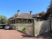
Aesthetic & Representative STATEMENT OF SIGNIFICANCE No 33 Alexandra Road is a single storey house constructed in limestone, brick and rendered brick with a tiled roof. It has historic and aesthetic value for its contribution to Richmond's high concentration of predominantly Federation and Inter-War period houses and associated buildings. The place contributes to the local community’s sense of place. The place has exceptional aesthetic value as a Federation Bungalow. The place retains a moderate to high degree of authenticity and a high degree of integrity. The additions have little significance. AESTHETIC SIGNIFICANCE No 33 Alexandra Road has exceptional aesthetic value as a Federation Bungalow. It retains most of the characteristic features of a dwelling of the type and period. HISTORIC SIGNIFICANCE No 33 Alexandra Road has considerable historic value. It was part of the suburban residential development associated with the expansion of East Fremantle and the subdivision of Stephen Henry Parker and James Morrison’s and then Walter Easton’s Estate from 1901. SCIENTIFIC SIGNIFICANCE N/A SOCIAL SIGNIFICANCE No 33 Alexandra Road has considerable social value. It is associated with a significant area of middle class Federation and Inter-War period development which contributes to the community's sense of place.
No 33 Alexandra Road is a single storey house constructed in limestone, brick and rendered brick with a hipped and gable tiled roof. It is a fine expression of the Federation Bungalow style. In the 1970s two extensions were made to the original building. A studio was also constructed in the 1970s and another extension in the 1990s. It is asymmetrically composed with a thrust gable bay and a part width return hip roofed verandah. The verandah is supported on timber posts with post brackets. There is a vertical timber balustrade that spans between the posts. The verandah flooring and balustrade were replaced in 2014. The half timbered, gable bay features a pair of double hung sash windows. There is a central entry door with a hopper light flanked by sidelights and a French double hung sash window. Particular features of the house include its roofscape with jettied half-timbered gables and chimneys with rendered caps. There are rendered string courses and decorative sills. The place sits on a limestone foundation. The place retains its form and most of its details albeit the extensions and modifications. There are additions to the rear. The original tin roof has been replaced by tiles. The place is consistent with the building pattern in the Precinct. The place plays an important role in the pattern of development of a middle class suburb. CONSTRUCTION MATERIALS Walls – Limestone, brick and rendered brick Roof – Tiles PHYSICAL SETTING The residence is situated on a sloping site with a traditionally detailed picket fence on the lot boundary. The fence is a later addition from the 1990s.
Historic Theme: Demographic Settlement In September 1883 Stephen Henry Parker and James Morrison of Perth commenced subdivision of 65 acres of land to the north of Canning Road. The subdivision occurred at Swan Locations 63, 176, 219 and the south western portion of Swan Location 306. The subdivision included Preston Point Road, Alcester Gardens, Wolsely Gardens, Victoria Road, Alexandra Road, Parry Avenue, and Salvado Avenue. The Richmond Precinct was owned by Walter Easton and was named after the town of Richmond where Easton lived in England. In 1901 Easton’s sons subdivided Windsor Estate. New streets to the subdivision of the Windsor Estate were named after various members of the Easton family; Walter, Gill, Stratford and Morgan (later Osborne Road). Initially lot sizes were generous but sold at a slow rate. The initial development of the Richmond Precinct occurred at Canning Highway and Preston Point Road. Substantial residences were developed on these streets giving precedence to the future development of Richmond. The distinct architecture of Canning Highway and Preston Point Road distinguish Richmond from the surrounding area. By 1913 there were approximately 40 residences in the area between Preston Point Road and Alexandra Road. Osborne Road, Windsor Road and Gill Street had several buildings apiece by 1913. By 1931 approximately half the lots were developed. In 1921 Richmond Primary School was developed between Windsor and Osborne Road and several Inter-War residences were developed in the immediate area. In the 1930s the Workers’ Homes’ Board developed a number of weatherboard, asbestos, brick and tiled residences. Inter-War style front porches were preferred over Federation style full width verandahs. Redevelopments have occurred throughout the Richmond Precinct. Large lot sizes have allowed Richmond to be subject to the redevelopment of group and multiple housing. However, significant clusters of heritage dwellings remain throughout. HISTORIC THEME Demographic Settlements - Residential Subdivision
Integrity: Very High
Excellent
This information is provided voluntarily as a public service. The information provided is made available in good faith and is derived from sources believed to be reliable and accurate. However, the information is provided solely on the basis that readers will be responsible for making their own assessment of the matters discussed herein and are advised to verify all relevant representations, statements and information.